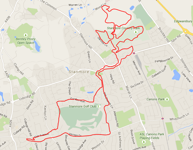
A stroll along the quiet lanes of Harrow Weald and Stanmore including a circumnavigation of Stanmore Country Park, a visit to a huge unexplained hole in the ground, and culminating in a navigation around Stanmore golf course via a footpath crossing the old rattler railway.
As with all walks on this blog, you start your journey by turning on to College Avenue and heading downhill towards the Duck in the Pond pub.
After appox 100 yards take the first left on to College Hill Road and immediately turn right on to The Avenue. Continue along the pleasant suburban road until you reach the junction with Kenton Lane when you turn left and then immediately right on to the Highway.
Proceed along the Highway and start to ascend the step hill with 1930's "Metroland" house's to each side of the quiet roadway. At the end of the road, and upon reaching the summit, you can pause for a breath and look back upon a vista of suburban sprawl interspersed by the spire of St Mary's church and the green swath at Harrow on the Hill.
We continue through the traffic barriers at the end of the road, and continue along a pleasant footpath between large, spacious and attractive 1980's built detached housing . We continue along the properties private estate road and arrive at a junction with one of Harrow Weald's more wealthy roads, Gordon Avenue.
Gordon Avenue was originally laid out at the end of the 19th century by the proprietor of the hotel that occupied the Bentley Priory site. Built as an access road for the railway station at the terminus of the "Rattler" extension to the Euston - Birmingham railway line. As with the road, the railway extension line was built largely at the expense of the hotels wealthy proprietor Frederick Gordon.
The land the road and accompanying house's are built on formerly formed part of the substantial and beautiful "Stanmore Park Estate" owned by the founder of "Drummond's Bank "Andrew Drummond, and later owned by George Glynn , founder of Williams and Glynn Bank.
The estate was gradually sold off piecemeal for housing in the early 20th century, with the properties developed all being of a substantial size, and situated adjacent to the newly formed Stanmore Golf Course, which was built across many acres of the former estate.
These acres including a man made mound known as "Belmont" due to is bell like shape, originally built as a view point and folly for the Duke of Chandos who lived in the adjacent "Cannons Estate".
The surrounding settlement still being known as "Belmont".
However, a large area surrounding the mansion house remained as open space when the main property became a school, and then a Balloon Station for the RAF. Unfortunately, within the last few years, even this land was developed and the remnants of the once glorious estate are a lake less than half its original size, and soulless modern housing and flats.
Returning to our mini marathon, we turn right on to Gordon Avenue and continue past large and substantial properties, although only two of the original Victorian mansions survive in their original state.
 |
| One of the remaining Victorian Houses |
As you proceed along Gordon Avenue, on your right are a
strange but not unpleasant grouping of substantial detached Victorian housing,
sixties built semi’s and flats, and recently constructed large detached houses
with neoclassical columns and Italianate design.
As detailed earlier, these properties sit on the former fields of the Stanmore Park Estate and were originally substantial mansions with outhouses and a considerable amount of land laid out as gardens.
As detailed earlier, these properties sit on the former fields of the Stanmore Park Estate and were originally substantial mansions with outhouses and a considerable amount of land laid out as gardens.
It is for this
reason that most of the original houses have been demolished to make way for
low rise blocks of flats and small cul-de-sacs comprising of expensive but relatively much
smaller semi-detached and detached housing.
Behind these developments remain the green wide open spaces
of the original estate, as the land is now occupied by Stanmore Golf course and
the grand clubhouse of Stanmore Golf club.
On the left of Gordon Avenue, opposite those just detailed,
there are no original Victorian or Edwardian properties remaining but yet again, numerous
new developments utilising the original large plots.
As you reach the end of this stretch of road, you reach a sharp left bend with the entrance road to the golf club to your right, and continued urban development to your left.
As you reach the end of this stretch of road, you reach a sharp left bend with the entrance road to the golf club to your right, and continued urban development to your left.
Approx. 100 yards from the apex of the bend, you reach a
number of old houses that sit between the road and Temple Pond.
Temple Pond was the largest water feature of the Stanmore Park Estate, and sat behind the mansion house with lawns running down to its banks. The lake was formed by damming the small brook that originates on the elevated land of the adjacent Bentley Priory Estate.
The brook leaves the lake between the apex of the bend earlier described, and the stone pillared and still existing former east entrance to the Stanmore Park Estate grounds. It continues across the road through a wooded enclosure that has a pleasant short footpath winding its way alongside the small river until it returns to a culvert that runs under Woolverton Road and onward to Stanmore marsh.
 |
| Old map of Stanmore Park and Temple Pond |
Temple Pond was the largest water feature of the Stanmore Park Estate, and sat behind the mansion house with lawns running down to its banks. The lake was formed by damming the small brook that originates on the elevated land of the adjacent Bentley Priory Estate.
The brook leaves the lake between the apex of the bend earlier described, and the stone pillared and still existing former east entrance to the Stanmore Park Estate grounds. It continues across the road through a wooded enclosure that has a pleasant short footpath winding its way alongside the small river until it returns to a culvert that runs under Woolverton Road and onward to Stanmore marsh.
Returning to Gordon Avenue, we continue forward around
the gentle right handed bend until we meet the junction with Old Church Lane.
On your immediate right is the former Stanmore Station located at the head of the rattler line built to service the former hotel at Bentley Priory.
However, as you may have guessed, it is no longer a station, as the line was torn up in the early 1960’s after Dr Beechings decision to decimate local railways.
The former railway station building has been converted in to a private dwelling, although its former use can clearly be seen by those in the know.
 |
| The entrance to the Manor House |
We continue and pass the site of the former Manor House
situated to our right, now occupied by a faux 15c building built in the early
20c, and to our left a number of new developments built on the site of more
substantial Victorian detached villas.
To our left, we soon pass a series of 17c terraced
properties, one of which was smithy, which are associated with both the old
Manor House and the Rectory which stands on a small road behind them.
 |
| Church House and Cowman's cottages |
Behind these buildings are Bernays Gardens, which were once part of the old manor house gardens.
The gardens are now open to the public, and take their name from the Bernays family who were former rectors of Stanmore Parish Church, St John the Evangelist, which stands opposite.
We are then at the end of the road where today, Old Church
Lane forms a junction with the Uxbridge Road.
Turning right will take us in to the centre of Stanmore, and to the left Harrow Weald, via Brockhurst Corner and the public house formerly known as “The Leefe Robinson”, named in memory of the first British WW1 airman to shoot down a German Zeppelin.
Leefe Robinson is himself buried just 50 yards away in a section of Harrow Weald Cemetery, and is entombed beneath an elaborate grave that is regularly decorated with poppies and other WW1 memorabilia and regalia.
Returning to the end of Old Church Lane, we are confronted
with the strange occurrence of two churches standing side by side, encompassing
a large cemetery plot, crumbling ruins of the 1632 church and the current
church building, which had the foundation stone laid by the dowager Queen
Adelaide in 1850.
The churchyard contains the ruins of the old brick church of
St John the Evangelist, built in 1632, and the new church, which was built in
1850 when the old church was too small and also found to be unsafe. The parish
had strong connections with the many local dignitaries with estates in the
area, to whom there are notable monuments in the church and churchyard.
These included Stanmore Park, Stanmore Hall and Bentley Priory, the latter at one time the home of Lord Abercorn and Lord Aberdeen, whose son Douglas Gordon was Rector and one of the donors of the new church.
At this junction we turn right on to Church Road and continue towards the shopping area where the road becomes The Broadway, which unfortunately has no remaining buildings of antiquity or interest, with 1960’s and 70’s retail redevelopments lining both sides of the road. We pass the junction with Stanmore Hill and continue passed a series of modest shops, coffee houses and cafes.
Just before we arrive at a cross roads, we encounter one of the oldest buildings in Stanmore. To our right is a terrace of timber-framed two-storeyed tenements, nos. 57-65 the Broadway, built in the early 17th-century as one house, possibly as an inn, but with later doors and windows.
Sources quote that the building is plastered outside and contains, in No.59, an elaborate chimney piece and panelling. It is reported that despite the loss of a ninth bay at the western end, the jettied upper storey facing the street for 98 feet is unequalled in Middlesex and one of the longest continuous jetties in the country.
 Returning
to our walk, we turn left from The Broadway onto Dennis Lane and climb
uphill passing Oak Lodge Close and Valencia Road on our right. After a
short while we turn right in to an unnamed short road that leads in to
Stanmore Country Park.
Returning
to our walk, we turn left from The Broadway onto Dennis Lane and climb
uphill passing Oak Lodge Close and Valencia Road on our right. After a
short while we turn right in to an unnamed short road that leads in to
Stanmore Country Park.
On entering the park take a
moment to study the large notice board and map and follow the route for
the left loop which takes you along wooded paths inter-spaced with
small clearings.These included Stanmore Park, Stanmore Hall and Bentley Priory, the latter at one time the home of Lord Abercorn and Lord Aberdeen, whose son Douglas Gordon was Rector and one of the donors of the new church.
At this junction we turn right on to Church Road and continue towards the shopping area where the road becomes The Broadway, which unfortunately has no remaining buildings of antiquity or interest, with 1960’s and 70’s retail redevelopments lining both sides of the road. We pass the junction with Stanmore Hill and continue passed a series of modest shops, coffee houses and cafes.
Just before we arrive at a cross roads, we encounter one of the oldest buildings in Stanmore. To our right is a terrace of timber-framed two-storeyed tenements, nos. 57-65 the Broadway, built in the early 17th-century as one house, possibly as an inn, but with later doors and windows.
Sources quote that the building is plastered outside and contains, in No.59, an elaborate chimney piece and panelling. It is reported that despite the loss of a ninth bay at the western end, the jettied upper storey facing the street for 98 feet is unequalled in Middlesex and one of the longest continuous jetties in the country.

Stanmore Country Park is a 30.7 hectare public park, Local Nature Reserve and site of Metropolitan Importance for Nature Conservation and is now owned and managed by Harrow Council.
The park was originally part of the grounds of an eighteenth century mansion called Warren House.
The history of Warren House dates back over 200 years. In the 1700's, the
land owner at the time, Henry James Brydges - Earl of Carnarvon and first Duke
of Chandos, built a substantial Manor House property and owned the nearby Dower house and Bowling Green
house. The main entrance to the house was from Stanmore hill but is now Wood Lane.
Warren House was originally a small scale cottage for the warrener,
an obsolete term today meaning a person employed to supply rabbits for the Lord
of the Manor, to take care of game and wildlife and also a general bailiff.
In
1714
the rabbit warren of Stanmore Common covered some 44 acres. Much later
in
the 18th century however The warren developed into a large rambling
house by Henry James Brydges - Earl of Carnarvon and first Duke
of Chandos,as detailed above.
In time the Manor house was sold off by trustees of the Brydges family to pay off the debts of a contemporary Duke's son.
In 1780 James Forbes of the East India Company, purchased part of the estate of the second duke of Chandos which included Warren house Dower house and Cloisters wood and had adorned the grounds with the first pieces of Hindu sculpture to be seen in England.
 |
| Warren House - photograph of Warren House borrowed from -
Stanmore Tourist Board.org.uk
|
In time the Manor house was sold off by trustees of the Brydges family to pay off the debts of a contemporary Duke's son.
In 1780 James Forbes of the East India Company, purchased part of the estate of the second duke of Chandos which included Warren house Dower house and Cloisters wood and had adorned the grounds with the first pieces of Hindu sculpture to be seen in England.
It is reported that the main plants in grassland areas are common bent and Yorkshire fog, with tufted hair grass in damp areas.
 |
| Stanmore Country Park woods |
Bird life is also abundant within the park which contains several members of the tit family, blackbirds, magpies and crows. The park also is home to tawny owls, buzzards and sparrowhawks.
Returning to our walk ,we continue on the left loop until we have almost circumnavigated the circuit, and we come to a pathway on the left that passes over a stream by way of a small wooden bridge. We leave the woods and climb up a fairly steep path through thick grasslands until we reach a wider path. At this stage we can look back and take in a view that reveals just how thickly wooded the area comprising the country park is.
 |
| Viewpoint |
This wide open space is known as Wood Farm, and from a viewing platform situated at a seating area, magnificent views of Harrow, Stanmore, the whole of the London basin and the distant Surrey hills are available.
Wood
Farm
comprises 59 acres of rough grass and scrub lying south of Wood Lane
and has now been incorporated in to the Stanmore Country Park that is is
situated adjacent to.
 |
| View from Wood Farm |
The
acres of Wood Farm were formerly used as a pig farm and then as a
landfill
site but have been transformed by moving earth, planting trees and
adding a
layer of topsoil. There is a large pond with abundant reeds and
vegetation, although I am unaware as to any species of fish currently
living in its waters.
From
the top of Wood Farm, we take the left hand path and descend in a
circular fashion until we pass back in to the woods of the country
park.
We now retrace our steps and enter the right loop pathway.
We now retrace our steps and enter the right loop pathway.
This
path takes us through heavily wooded terrain with numerous small paths
running off in various directions. With Wood Lane open space to our
left, at the eastern end of the park we encounter an ancient huge hole
in the ground, which due to the tall trees and thick vegetation, you are
not aware of until you are at its very edge.
Known as Forty Acres Pit, the origins of this huge crater are hard to come by, although it is believed by some local historians that when the area was first settled, flints , chalk or clay may have been dug from the site for building materials. However, others believe that it was created in the1700's as a reservoir or pond, and formed part of a system supplying water to the nearby "Cannons Estate", the home of the Duke of Chandos.
Known as Forty Acres Pit, the origins of this huge crater are hard to come by, although it is believed by some local historians that when the area was first settled, flints , chalk or clay may have been dug from the site for building materials. However, others believe that it was created in the1700's as a reservoir or pond, and formed part of a system supplying water to the nearby "Cannons Estate", the home of the Duke of Chandos.
 |
| Woods in Stanmore Country Park |
Completing
the right loop, we re-emerge at the entrance / exit site on Dennis
Lane. We turn left and then left again on to Valencia Road, a private
road with large expensive houses built in the 1920's and 30's. Some are
in the Art Decor style and are very impressive.
Passing
these houses we encounter a junction with Kerry Road, which if we turn
left will take us back in to the country park. However we turn right and
descend the slight slope until we reach the junction with the London
Road, opposite Stanmore London Underground Station. Turning right we
proceed back towards the Broadway and the shops of Stanmore.
We
pass through the shopping area and arrive back at Old Church Lane,
where we turn left towards Gordon Avenue. However, we do not turn in to
Gordon Avenue, but continue forward passing the site of the original
Saxon Stanmore Church, which gives the road its name.
We
turn right on to Wolverton Road, which is a dead end road, and continue
to its end where we pass through an alley that brings us out on Belmont
Lane, a road based on an ancient track that can be viewed on the
earliest available maps of the area.

Follow
Belmont Lane to its junction with Wemborough Road and turn right.
Continue to follow the road until the main road bears left but we
continue straight on following Wemborough Road in to a cul de sac.
At this stage we take a pathway that connects Wemborough Road to Vernon Drive.
The pathway crosses the old "Rattler" railway that ran from Harrow and Wealdstone to Stanmore, and the disused track-way and embankment can still be seen, and has been turned in to a separate pathway that takes you to Belmont Circle.
The pathway crosses the old "Rattler" railway that ran from Harrow and Wealdstone to Stanmore, and the disused track-way and embankment can still be seen, and has been turned in to a separate pathway that takes you to Belmont Circle.
We
then continue along Vernon Drive, passing the entrance to the public
footpath that climbs steeply and crosses Stanmore Golf course, the road
becomes Mountside, and we continue forward until we reach the Duck in
the Pond, where you can rest your feet and enjoy a cold pint of lager
or tipple of your choice.


